Friday 14 December 2007

World Snow News 24: 14th December 2007

Welcome to this week’s world snow roundup from www.snow-forecast.com. Our sponsor for this edition is Snowbrainer - an online ski & snowboard hire site where you book online and collect in the resort saving you both time and money. Readers of our newsletter qualify for a massive 40% off the shop prices in France on all bookings 6 or more days for any week of the season. Just visit http://www.snowbrainer.co.uk/index.asp?affiliate_code=SF4040

Summary:

  • Parts of French Alps see 1m of snow in time for Christmas
  • Settled but cold week ahead for Alps
  • Ice Storm hits US, brings a little snow to resorts
  • Conditions in Canada set to improve again
  • Snowstorm forecast for Appalachians this weekend
  • Fresh snow in Pyrenees at last
  • Glencoe saved by Invocas
  • Resorts in Lebanon and NW Spain see fresh falls - now close to opening

It is not often that mid December finds skiers spoiled for choice. The combination of a strengthening La Niña in the Pacific and a weak North Atlantic Oscillation means that most of the ski areas of the world are currently in great shape. So many areas saw fresh snow last week that it begins to look like calling this winter a good season is a foregone conclusion. For much of North America, where conditions in the States have improved dramatically during December, it's unlikely to take a turn for the worse. Even so, despite the great start, European resorts are more vulnerable to mild winds as well as long periods without fresh snow so it's a bit early to be confident about the peak months. With an intense high pressure system now building over the Alps it won't take too long before all this wonderful fresh snow is tracked out. The piste cruisers won't mind if it doesn't snow before Christmas, but off-piste powder hounds may be more interested in the snowier weather around Europe's more obscure edges.

It's simpler to mention the few places that don't have great conditions right now than list all those that do. In previous editorials I was pessimistic about the prospects for resorts in Southern California, but even here there they have had about 25cm of snow over the past week. In no particular order, here are some places that are not doing so well this season. Scotland doesn't have great snow depths and is subject to mild SW winds - probably the last thing the new owners of Glencoe wanted to hear. The Pyrenees have seen some snow at last, but the base isn't yet deep enough to be too excited about - but at least they can look forward to new snow next week. Further south, The Sierra Nevada has received very little snow so far this season, and there isn't much sign of that changing. In Scandinavia the snow is getting a bit too old and hard packed for some tastes and with little prospect of fresh snow next week, there are better destinations to aim for.

The Alps
The fresh snow has fallen much as expected. Over a metre fell in the northern French Alps. Valais in Switzerland did well too. Indeed, no major Alpine resort missed out entirely, even if Isola 2000 saw just 2cm. The present mid-week dry and cold weather has followed as forecast too, but the big mistake in last week’s editorial was predicting that Atlantic fronts would return around now. In reality they got about as far as Ireland and stalled. Instead, the ridge of high pressure crossing the Alps quickly became much more intense than expected and now it looks like it is going to sit over central and western Europe for at least a week as a cold stagnant pool of air. The worry is that once established, it could prove reluctant to shift. The North Atlantic Oscillation isn't driving depressions into Europe with the usual vigour and anticyclones over continental Europe at this time of year cool down so quickly - the combined effect risks ringing a sudden end to the pattern of frequent Alpine snowfalls just as we started taking them for granted. Easterlies with snow flurries are still affecting Austria and the Dolomites. These look like they may spread across the Italian and French Maritime Alps for a time with much more significant snow for the Apennines. These cloudy easterlies will fade away by Sunday and these southern Alpine areas will then join the rest of the Alps in having good weather and excellent fresh snow conditions - certainly the best conditions of the season so far in much of France and Switzerland where upper level snow depths are near the 2m mark. There is just a hint that if the anticyclone drifts over Britain as expected, snowy SE winds may return to the southern areas of the Alps in France and Italy next week. Atlantic fronts looks like they will make another attempt to invade Europe in 5 or 6 days as a deepening depression forms off Portugal. As that depression slides away northwards there is a risk of heavy snowfall where it comes up against the cold continental air. It is a long way off, but central and northern Spain, SW France and perhaps even southern Britain are at risk of a period of snow from Thursday through the weekend and it is just possible that the cold air will not have been overcome before Christmas. Hopefully the low pressure will track further into Europe than we expect.

Pyrenees and Iberia
The Pyrenees and Cantabrian resorts got the snow that we forecast last week. Although they saw nothing like the depths reported in the French Alps, it was nevertheless very welcome because it had been so dry for so long - something like 15cm of snow fell in Andorra, more to the west. Current models predict a low latitude Atlantic depression next week will run up along the Portuguese coast next week. Although the wind will tend south over Spain, the airmass is quite cold and we should see some mid-week snow from this system on nearby mountains like Serra da-Estrela in Portugal and the Cantabrians too. It should be sufficient to get places like San-Isidro open. SSE winds, squeezed between this low and the European anticyclone blowing off the Mediterranean may also bring further snow to the Pyrenees - more especially to the eastern resorts; places like Masella in Spain.

Scotland
The Scottish season spluttered to life a couple of weeks ago and since then the lifts have occasionally been running at Cairngorm but yesterday they were again closed because of high winds which have whipped away a lot of the snow here and almost all of the cover from nearby Lecht. The Ptarmigan bowl should have sufficient cover to allow skiing again once the wind subsides but overall it's not a good forecast for Scottish resorts because it is on the wrong side of the European anticyclone which means it is currently picking up mild SW Atlantic air. It's above freezing with severe gales on Thursday afternoon - especially in the west. This is something that might come as a surprise to people from England where it is mostly cold and frosty. As the high shifts towards Britain, we should at least sea both the wind and freezing level fall next week but any surviving snow may turn icy in these conditions. Apart from a few flurries off the N Sea, no substantial snow is forecast during the next seven days but a chance of better conditions in time for Christmas. Following a successful purchase today from Invocas, Glencoe is open for business and awaiting suitable ski conditions. We wish them the very best of luck - on a good day, Glencoe offers the best skiing in the British Isles and it is heartening to hear that it will be business as usual in 2008.

Scandinavia
We mentioned the prospect of cold and dry air edging in from the SE and that is just what happened. It was initially good news but after a few days it has left the pistes quite hard. The mild SW flow will clip northern Norway at first, but otherwise a predominantly cold and dry prospect for at least a week.

Eastern Europe
Resorts in Bulgaria are in good shape following more snow on Wednesday. Only Bansko is open right now (with 1.6m at the top) but all resorts have great conditions and can expect a period of heavy snow on Saturday night followed by a cold week with a mix of sunny and cloudy days. Neighbouring Greece is less well known to foreign skiers which is a shame because nowhere on the Greek mainland is very far from a ski resort. The local Aegean climate has thrown up a few climatic oddities like the spectacularly snow-sure (and exceptionally scenic) Mount Pilion, near Volos - a snow magnet when an easterly blows and with ideal conditions forecast, we expect heavy falls there in the week to allow them to open next weekend. Kaimaktsalan near the northern city of Florina is already fully open and is also expecting more snow through Saturday. Sunday should be perfect. Most Athenian skiers head to Mount Parnassos, above Dephi on the northern shores of the Gulf of Korinthos. A day pass costs just 13.5 Euros on quiet weekdays. There is currently 15-20cm base and temperatures are -10C and with two spells of snow expected next week; one on Saturday and another on Monday, and according to local oracles, it should open for skiing very soon. Turkey has far higher mountains than Greece and its high plateau gives it a much more continental climate with bitterly cold and often snowy winters. Scattered light to moderate snowfalls are forecast for the next week. Heaviest snow is forecast for the Balkans at resorts like Tara in Serbia and Montenegro - this snow will be carried on cold east winds first to the Apennines of Italy, and later for Corsica and Sardinia too.

Hermon in Israel has just a dusting of snow at the top and the next 7 days will see a mix of rain and snow so it probably won't open until January. Higher altitude resorts in Lebanon have a much better cover and need just one more fall to open and we expect there to be sufficient new snow this week to allow opening next weekend and if Friday's snow is as heavy as expected. Perhaps Faraya may open as early as Saturday 15th.

Canadian Rockies and West Coast
After a relatively dry spell, the winter storms are gathering again. Whistler is currently 86% open and has about 130cm of base following 10cm of snow three days ago - it's cloudy and cold and there are light flurries of snow. There is a great deal more snow in the forecast. The problem may be finding long weather-windows to enjoy it because apart from a brief hiatus mid-week when the sun may come out for a few hours, it looks like it will stay cloudy and snowy for much of the next 10 days. These systems will penetrate well inland too, bringing regular top-ups at the usual suspects in Alberta where conditions are already excellent.

American Rockies
The bare slopes of late autumn have been rapidly transformed by a succession of weather systems and in the space of 2 weeks, snow accumulations have caught up with European levels - Breckenridge and Copper Mountain now both have over a metre. The most recent notable system was an ice-storm that brought chaos to several states in the mid-west and has left many there without power as cables and branches snapped under the weight of ice. As the system moved away into Canada, rain turned to snow in the polar air that followed. Most of the weather action was west of the Rockies but many resorts there saw a light covering. There is light snow around the Colorado Rockies over the next day or so too. Settled weather following on as pressure builds next week.

California
Northern California and Nevada may have been late starters this season, but they are catching up fast. A few weeks ago it was warm and sunny but lately it has turned cold and snowy. It went straight from summer to autumn. 40cm of fresh snow was reported from resorts around Tahoe last week and the forecast could not be better - a sunny weekend for making fresh tracks before another system brings more heavy snow on Tuesday and staying cold too. Even Southern California received some snow last week, with 25cm falling on the local Los Angeles resorts - places where they don't really care if it snows as long as it is cold enough for snow-making, and happily it is - more trails are being opened daily at the local LA resorts.

Appalachians
Again, we have to look to the Gulf of Mexico to see what the weather has in store for the eastern USA and Canada and the Appalachian resorts. A deepening low is forecast to quickly track NE over the weekend bringing some especially ugly weather to a wide region - strong wind, heavy rain, snow and more ice. It's a complex weather picture that is evolving quickly so I suggest you closely watch the resort forecasts because the details will change. Stowe in Vermont is typical of resorts in the region in having between 40 and 140 cm of snow at present following a light covering of 7cm a few days ago. We expect all Appalachian resorts to have a very snowy weekend as this system passes. In Canada, Mount Saint Anne did well last week too. It has partly cloudy skies, with temperatures reaching close to -20 degrees Celsius on Thursday following 18cm of snow on Tuesday. Staying bitterly cold too. It will be Sunday before the passing storm delivers the next heavy fall of snow. Excellent sunny skiing conditions will follow across the Appalachians before a second system takes off on a similar track in a week.

Hawaii
Surely a typo? Not at all. Daytime temperatures on the 4200m summit of Mauna Kea on the Big Island average -4C in the winter. It's usually well above the rain-forest clouds but easterly storms can bring occasional deep snow. With vast tracts of cinder, it only needs a moderate fall to allow skiing. It sometimes gets good enough to tempt local surfers out of the sea and on exceptional winter days the road up to the summit sees trucks ferrying local skiers and boarders who can enjoy a respectable 1000m of wide tropical vertical if conditions are right and they are right now. There was once such big storm 6 days ago and the snow cover is still excellent. Expect cold weather and low temperatures and snow showers over the next 7 days.

Tuesday 4 December 2007

World Snow News 22: 2nd December 2007

First, sincere apologies to users for a patchy service from Snow-forecast at the end of last week. Our website comprises many hundreds of thousands of pages, most of which usually update at least two or four times per day. In order to balance the load, this information is distributed between several servers. On Thursday, one of these computers developed an intermittent fault that prevented some updates. We didn't spot the problem right away. We moved its content to a spare machine but it took some time for this change of address to be recognized by web routers. Some users have written in to say that they saw a mix of missing, old and up to date content between Friday until Saturday lunchtime - we are very sorry if you were affected. Static maps were worst affected, resort forecasts slightly affected and dynamic maps were unaffected. As of Saturday lunchtime, all systems were running normally and all users are viewing the current forecast on the new server. Should a similar problem occur again, we are confident that we have found a solution for making new servers visible much faster.

Summary

  • A change to stormy Westerly winds for Europe
  • Heavy snow expected across northern Alps
  • Very mixed weather for Scandinavia and Scotland
  • Snowfall for the American Rockies at last
  • Pyrenees to see first heavy snow in a week – perhaps.
  • Whistler is the place to be next week

In meteorological terms, December marks the official start of the northern winter. This year, over Europe we have seen a switch away from the decidedly wintry weather pattern that dominated autumn to a much more autumnal weather pattern. Whereas autumn was characterized by cold northerlies and record breaking snowfalls across the Alps, this has been replaced by disturbed westerly Atlantic air-stream – often stormy over Britain and Scandinavia. If this had happened more than a week or two ago, the attendant warmer temperatures and rain would have melted much of the Alpine snow cover. Arriving later, the Atlantic flow is now cool enough for snow rather than rain to fall across much of the Alps. Very little of this disturbed weather reaching the Pyrenees where it remains mostly settled for another week. Across the Atlantic in America the weather patterns have improved. A weather system developed over Baja last week and tracked NE across the continent to the Great Lakes. This system has brought a very welcome fall of snow to many Rocky Mountain and Appalachian ski areas as well as the vast number of little ski areas in between.
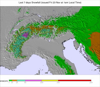
The Alps

Last week was mostly fine but the weather is quickly becoming steadily less settled. Not everywhere was dry last week – Flachau in Austria reported 20cm of fresh snow on Tuesday. Many more Austrian resorts have opened this weekend leading to fresh tracks for many, even if the snow is a few days old. Snow depths remain very impressive for the time of year.

With low pressures tracking well to the north of the Alps, the forecast is for the heaviest snow to be confined to the northern areas of the Alps where 20 or 30cm falls will be typical. Favored areas will include many parts of the French Alps that have missed out on the record November dumps in Austria and Switzerland. For example, there is just 50cm of snow on the glacier at Tignes compared with over 2m at Kaprun. Both will see new snow very soon, but it will be windy. The heaviest snowfalls will be on Monday with freezing levels about 1500m in France and 500m lower further east. It looks like there will be a brief mild and settled spell for all mid-week before further westerlies blow in more snow and falling temperatures later in the week.

Pyrenees and Iberia

High pressure has been centred near the Pyrenees since summer. Last week, I mentioned that there was a chance of a snow-bringing Easterly flow to be established before Atlantic air pushed in but these hopes were unfounded. With high pressure once again located around Iberia, forcing fronts to track further north, we don't see much prospect of significant snow for another week, apart from a few bits and pieces, mainly in the west at places like Formigal. Snow cover at the resorts is currently very sparse compared with the Alps. It looks like a secondary low may form in the Bay of Biscay on Saturday. That's a long way off, but if this goes according to plan it will bring very welcome snow both to the Pyrenees and the Massif Central. Even the Cantabrian Mountains of northern Spain should also see snow from this system. Further south, a dry week in the Sierra Nevada. Still no sign of winter for Serra da Estrela in Portugal and the more snow-sure alternative Sierra de Bйjar across the Spanish border.

Scotland

Autumn may have been fairly settled but Atlantic gales are the theme for the week ahead. With low pressure nearby, it is going to be a very unsettled week. Freezing levels will vary greatly as the wind varies between mild SW and cold NW so expect a mixture of heavy rain and snow showers with a notably mild day on Tuesday. Later in the week the air tends much colder and periods of heavy and drifting snow should resume filling in between the snow-fences. Don't be too surprised if Scottish resorts open for skiing next weekend. The snowy weather will again extend right down the Pennines at times but we don't presently expect enough snowfall to allow any of the small English club fields to open yet.

Scandinavia

With a westerly flow Scandinavia is seeing the same unsettled picture as Scotland but unlike Scotland resorts are already open and places like Voss have 50cm of snow. The mild winds on Tuesday and Wednesday look like they will lift freezing levels above the resorts and bring some unwelcome rain before more windy and snowy weather returns later in the week. Even then, with low pressure staying to the West, it will remain milder than recently.

Eastern Europe

We expect widespread moderate falls of snow across mountain regions over the next few days. Heavier snowfalls for Turkey later in the week too but becoming drier further west. Borovets is reporting just 10cm of snow right now but the good news is that it is -7 degrees about the tops and there is fairly heavy snow forecast for Tuesday.

Canadian Rockies and West Coast

Whistler continues to enjoy good early season conditions with about 1m of snow across the upper mountain. We are expecting very heavy snowfall and low temperatures this weekend, not clearing until Tuesday or even Wednesday when conditions should be perfect for at least 4 or 5 days. Inland, around Banff, there are even lower temperatures with a prospect of powder snowfalls this week.

American Rockies

A weather system brought up to 23 cms (9 inches) of very welcome snow to parts of the Rockies last Wednesday. Steamboat (35cm), Jackson Hole (55/95cm) and Solitude all saw 10–15cm. Since then, ski resorts across Utah, Colorado, Arizona and New Mexico have benefited from a second and larger winter storm that is currently tracking across the continent – on Saturday morning Vail has reported 10cm of fresh and it is still snowing there. Previously snow-starved Durango reports 22 inches of fresh snow this morning and plans to open for the season tomorrow (Sunday). As it moves away east, this system will deliver a mix of snow, rain and freezing rain to much of the mid west and the Appalachians. The heaviest snow (more than 30cm) is expected to fall at small resorts west of the Great Lakes; obscure little ski areas in Minnesota that cater mainly for locals. Watch out for another mid-continental low to develop on Thursday and bring more snow to the American Rockies. Very cold right now around Tahoe but with mild weather mid-week before it turns much colder again. No fresh snow expected until Thursday and even then, just a dusting.

Appalachians

The snow affecting the mid-west will clip the inland Appalachians on Sunday but the heaviest snow will track through the Great Lakes region and later Quebec and Nova Scotia. That's good news for dozens of minor resorts that hardly anyone has heard of! Of the more famous resorts in this region, Mont Tremblant is well placed to see fresh snow from Sunday through Tuesday, followed by very low temperatures. They already have a 20–50cm base with a few cm of fresh snow on top.

The Snow-Forecast.com team

Friday 23 November 2007

World Snow News 21 - 23rd November 2007

Welcome to the latest roundup of worldwide snow conditions, together with weather prospects for the week ahead from www.snow-forecast.com.

First, a couple of announcements. Today saw the launch of our new website platform utilising the latest web platform. This will deliver a smoother user experience and also enable us to roll out many of the new features that have kept us busy for the past year.


If you are a member of the Facebook networking community, we have launched our own group which attracted over 900 members on its first day. This is a place for news updates, photos and a chance to meet other users of snow-forecast.com. Click here to visit.

Headlines

  • Exceptionally good early season conditions in Austria and parts of Switzerland - the best start to a season in 30 to 50 years.
  • A brief mid week outbreak of gusty Föhn winds is ending - cold conditions will return to the Alps by the weekend.
  • French Alps benefited from a 40cm fall of fresh snow and a brief mild spell has already given way to fresh snowfalls
  • Cold temperatures have arrived in California at last - snow-making is underway but the natural cover is still in short supply.
  • Western Canada continues to enjoy excellent early season conditions and more snow is forecast.
  • Telluride is the latest major Western US ski area to postpone its opening date this weekend as weather patterns stack against the Rockies this winter.

European Alps
November 2006 may have been the warmest on record in the Alps, but November 2007 has provided Austria, Germany and parts of Switzerland with the best early season conditions for at least 30 years.

Even before last week’s snow storms a number of Austrian ski resorts had already opened as much as six weeks ahead of schedule - Schladming-Dachstein opened its doors on 26 October and Kitzbuehel on 2 November. On Thursday night, heavy snow falls saw thousands of drivers left stranded on a highway outside Vienna - up to 50cm of snow fell and about 5,000 cars were involved in a 21km jam along the highway. This low altitude snow followed two days of heavy snow at higher elevations and overall accumulations at ski resorts were much higher. 120cm of snow fell around Davos and Klosters, and as much as 2.5m has accumulated on the glacier at Kaprun. Low temperatures ensured that the fresh snow stayed dry and powdery through the sunny weekend and several more resorts opened early to take advantage including Badgastein, Zell am See, Saalbach-Hinterglemm and Mayrhofen. The German part of the Alps also saw very heavy snow - deep fresh powder conditions where enjoyed by huge crowds at Garmisch-Partenkirchen last weekend. Bitterly cold temperatures at high altitude (below minus 15C at 3000m) rendered the snow on higher pistes sticky but off piste conditions were excellent from top to bottom. In Switzerland, The Jungfrau resorts of Grindelwald (45/115cm), Wengen (40/80cm) and Muerren (40/80cm) have impressive snow depths for the time of year too. They are only open at weekends until they open daily for the season from the 8th December. On Tuesday temperatures began to climb across the Swiss and Austrian Alps as the wind swung southerly. By Wednesday a gusty Föhn wind was strong enough to close glacier resorts and warm enough to strip away much of the snow below about 1500m from prone areas on the north side of the Alps, from Sion in the Rhone in the West, through Chur in eastern Switzerland (where a balmy 15 degrees was recorded) to Innsbruck where it was 13 degrees at 1am on Friday.

As pressure builds over Western Europe, the Föhn wind is steadily being replaced by a cold northerly - temperatures in some valleys will fall by 20 degrees in less than 24hrs! During the transition, there will be some new snow about - it's already snowing across the French and Swiss Alps and this will snow spread to Austria soon. We don't expect anything like the metre-plus falls of the previous system. Even so, we could easily see 20-30cm of snow in the French, Swiss and Italian Alps and only a little less in Austria. Snow clouds should clear from the west as the weekend progresses to leave a cold and settled week, though weather models are finely balanced with some having the snowy northerly persist for several days.

Eastern Europe
While snow conditions in Austria have made the headlines, neighbouring countries have also seen unusually good early season conditions but in these places the relatively low altitude means that some of the snow that fell a week ago has since melted.

The same system delivered heavy snow right across the Czech Republic, to Poland and Slovakia. A secondary depression formed south of the Alps and this one ran across Italy, the Balkans, Greece and eventually Turkey. Unfortunately, the most notable weather that resulted was widespread flooding for Greece and Western Turkey. Even so, high mountain areas across this region saw very heavy snowfalls and despite rising temperatures, much of this base remains intact at ski resorts from the Apennines of Italy to the Taurus of Turkey - even the summits of the Balearics saw some snow.

The next 7 days will see a return to cold weather. Settled at first but becoming increasingly snowy from Sunday onwards from the Apennines, through the Balkans, Carpathians Bulgaria and northern Turkey.


Scotland
It has been quite wintry over northern Britain lately. The cold northerly airflow that is heading for the Alps brought a period of snow to the Scottish Highlands on Thursday. With summit temperatures falling to -7C and gale force winds, conditions are very severe for the time of year. There will be further snow showers for the Grampians on Friday too. On Saturday, an Atlantic depression will pass north of Scotland bringing another spell of snow over the Highlands as milder Atlantic air comes up against the resident cold air. As cloud clears away, the northerlies will return and snow showers will last right through the weekend. Next week begins settled and frosty but there is some indication that high pressure will slip to the south of Britain allowing milder SW winds to cross Northern Britain.

Scandinavia
Whereas the present weather pattern is delivering Scotland a typical freeze-thaw cycle, in Scandinavia the warm spells are much closer to zero degrees and so a snow base has accumulated. In Norway, Geilo (5/5cm) is now open for winter snow sports despite a shallow snow base. 5cm of snow fell on Thursday morning and they have four pistes open. Dustings of snow also fell at the other open resorts of Trysil (25/30cm), Oppdal (40/40cm), Hemsedal (5/50cm) and Lillehammer (25/25cm). Voss (30/30cm) is scheduled to open on the 1st of December. The largest open ski area is at Spitzingsee (20/50cm) which has 18km of pistes open. We expect to see further snowfalls for resorts in Scandinavia over the weekend, more especially in SW Norway. If Atlantic SW winds develop next week, freezing levels will rise above the tops so make the most of present conditions just in case.

Pyrenees
High pressure has been anchored off Western Europe for two months with just brief periods of unsettled weather for the Pyrenees and other Iberian ranges - it is a weather pattern that favours the Alps, and more especially the eastern Alps. Apart from some light snowfalls from a bitterly cold northerly the next seven days promise yet more of the same - fine and cold over the Cantabrian Mountains and the Pyrenees. With temperatures of about -10C at 2500m, at least it will be cold enough for snow making. Weather models again indicate that a snow-bearing Easterly airstream may become established in 9 or 10 days time but confidence is very low - last time they predicted this it did not materialize.

Sierra Nevada
The southern outpost of European skiing is located improbably close to the Mediterranean, just a short distance from Malaga. At over 3500m, the Sierra Nevada is a respectably high mountain range and for now at least, it is home to Europe's most Southern Glacier, a boulder covered lump of ice beneath the towering north face of Mulhacen, (3479m). From a skiing point of view, the area is worth considering in poor Alpine seasons because it tends to do better in years that are poor in the Alps. Friday night and Saturday should see further fresh snowfalls before the weather becomes fine and cold again from Sunday. A similar pattern affecting the Atlas too - if anything the weekend snowfalls will be a little heavier here. As with the Pyrenees, the best hope for significant snow is if the weather models are correct in predicting that an Easterly flow will become established in a week or so.

Middle East
Political instability means that this fascinating winter sports region is mostly overlooked by outsiders. Some of the most consistent skiing in the region is to be found on the 3000m+ mountains of Lebanon. However, neighbouring Israeli skiers don't venture here and as a result much lower Mount Hermon, the only ski resort in Israel, is often full to capacity. Similarly, Iran offers a range of very high altitude snow-sure ski destinations that have incredible potential if only political tensions would subside. The ski season in the Middle East tends to begin a month or so later than in Western Europe but some years it allows skiing well into April - when snow does fall it can be heavy and in Lebanon in particular it often lies several metres deep. The week ahead looks mild and dry for Israel and Lebanon but unsettled, cold and snowy for the ski resorts close to Tehran.

USA
Heavenly Mountain Resort began making snow this week The Lake Tahoe snow sports season is therefore just days away if temperatures continue to cooperate. The West Coast's largest snow-making system can cover 70 percent of Heavenly's trails in machine made snow. Heavenly's opening day, scheduled for this Friday, November 23rd. Looking further ahead, we expect a welcome fresh fall of snow around Tahoe on Tuesday.

In marked contrast to Europe, snow depths in the Rockies are modest and with 46 cm of snow Vail is probably the best of the Colorado resorts - 10-20cm of snow is more typical of others.

A small area of snow is currently sinking across the Eastern Rockies as far as New Mexico and NW Texas bringing the first significant snow of the season to some resorts in these areas - very welcome, but probably not enough to kick start the season anywhere. So far this autumn such snow events have been few and far between and Telluride is the latest major Western US ski area to postpone its opening date this weekend as La Niña winter weather patterns favour the Alps and the Pacific NW and stack against the Rockies, especially the more southern States.

Across the other side of the continent, East Coast snow conditions are steadily improving following widespread Appalachian snowfall last week that extended coastwards to New York City. On the southern shores of the Great Lakes, there was localised heavy Lake Effect snow too.

Canada
Snow has also been falling on the east of Canada this week allowing Tremblant and Mont St-Anne to open in time for their weekend visitors. A low pressure system currently located over the coast of Maine is expected to bring another 15 to 30 cm of snow to the small resorts in Newfoundland, Labrador and Québec on Friday.

Moving west, Banff National Park looks cold and dry until Sunday when it will turn snowy and then stay that way through Monday. Bitterly cold too, with resort temperatures as low as minus 16C. Big White (38/38cm) and Silver Star (25/54cm) were scheduled to open on Saturday but this has been postponed until the 30th November. When you consider that Big White boasts and average of 7m of snow in a season, they plainly have some catching up to do but nobody should panic for at least another month.

The mid-station of Whistler reported 45cm of snow from the last weather system bringing the accumulation there to over 1m and the Glacier is open now too. The weather should stay fairly settled over the weekend - quite mild at first with only light snow flurries about the tops before colder weather and a more significant band of snow arrives on Monday.

Wednesday 14 November 2007

World Snow News 20: 14th November

This weekly editorial is sent to all current members of snow-forecast.com. Even after your membership has expired, you can still view current and archived editorials at http://snow-forecast.blogspot.com/ Our sponsor this week is Direct Travel Insurance - click here to check out their offpiste winter sports cover from only £15

Today’s editorial is a day earlier than usual. I will be perfectly honest about the reason - Early season conditions in Austria are currently so good that Rob, our trusty editor, has decided that he needs a break and can't wait until tomorrow. He was last seen heading out of the door with a snowboard, a very long ruler and a laptop, muttering something about needing to check if our Alpine forecasts have been sufficiently accurate. Given the conditions, I am sure he is not the only one making a flimsy excuse for taking a long weekend. Here is what he wrote before he dashed off to go "calibrating" - it looked like he was in a hurry and I can't help noticing that it's a bit briefer than usual, and what on Earth happened to Scandinavia? --
Nick (today’s editor).

~ ~ ~ ~ ~

Pyrenees
=======
With a blocking high over Western Europe for most of the Autumn, slopes in the Pyrenees, Sierra Nevada and Western Alps have mostly missed out on any early snowfalls.
A week ago I mentioned the prospect of things improving about now as an easterly flow develops over the top of a developing Mediterranean low. The weather has more or less cooperated, but unfortunately the flow is more Northeast than East and coming off the continent, drier than expected. We can expect low temperatures and only a dusting of snow over the weekend with the heaviest snow falling instead on the high mountains of Corsica. Early next week, we do expect a northerly flow over the Pyrenees to deliver light snowfalls over a wide area and by Wednesday, falling pressure promises to bring the first substantial snowfall of the season although once again there is some uncertainty because this is highly dependent on high pressure retreating far enough into the Atlantic.

European Alps
==========
There were very impressive snowfalls over Austria last week and accompanying low temperatures mean that most Austrian resorts are now in full winter conditions. It's about -15 degrees C at 3000m today. Langem am Arlberg had 112cm (44inches) of snow over 48hrs with winds reported to have peaked over 100mph (160km/h) here - strong enough to cause some damage. Nearby parts of Germany have also benefited from the snowfalls - Garmisch is open. At long last some of that snow has spread further west into the Swiss and French resorts. Nothing like as much snow has fallen here though things are improving right now. With this storm accompanied by drifting snow and following so quickly after a previous ones, it is difficult to say how much fresh snow actually fell - something like 50cm to 1m seems representative of most of Austria, heaviest in Salzburgerland where there are exceptional reports of 1.5m of snow and snow there is still falling. At Kaprun, it is now possible to ski down to Langwieboden.
The Austrian Tirol has generally seen about 50cm of fresh snow too. The problem with so much snow being accompanied by severe gales is that it has caused avalanche problems. The risk was so high that the road to Lech and Zurs was closed earlier in the week - the earliest time in the season that this has happened since 1974. Although it has been widely reported that this storm was a once in 30 years event, few commentators seem to have traced its origins right back to the remains of Hurricane Noel feeding warm and moist air into an arctic depression.

With low pressure slowly crossing central Italy form west to east over the weekend, an easterly wind will maintain low temperatures over the Alps. Snowfalls will slowly clear from the west over the weekend, with the prospect of especially good skiing on all of the Austrian glaciers once visibility lifts. Also very good at and any lower elevation resorts like Schladming that choose to open at the weekend. As the Alps lose the heavy snow, it will turn increasingly wintry over the Apennines of Italy. There is already a good base at many resorts - all of which are little known outside Italy and few visitors to Rome realise that there is such great skiing close at hand.

A lot of our users are no doubt wondering if and when the French and Swiss Alps are going to see a decent fall of snow. Before you contemplate changing your Christmas destination to Austria, don't panic - these areas are not entirely missing out. The good news is that there are moderate snowfalls and low temperatures from about Risoul north - that's pretty much everywhere apart from the Maritime Alps of France and Italy. 10-20cm of snow will be typical for the French and Swiss Alps with snow falling right down into the valleys. Because of the nature of the cloud profile, snowfalls will likely be heaviest at about 2000m with lighter snow on the glaciers. Clouds clearing away on Saturday morning to give a fine weekend with much lighter winds. Turning unsettled and increasingly snowy by the middle of next week.

Eastern Europe
===========
East of Austria, it has also been a cold and snowy week - especially over the Czech Republic. We expect very heavy snow over the Balkans adding to what has already accumulated last week. A brief mild spell over Bulgaria will give way to heavy snow there at the weekend.

Scotland
======
The northerly storm surge that threatened flooding along the North Sea coast last week was accompanied by heavy drifting snow of Eastern Scotland. Milder Westerly winds melted much of it and the slopes at the Lecht were soon back to grass and heather. The nearby Cairngorms were just high enough for some of the snow to survive on higher runs. A return to cool and showery northerlies is currently bringing further snow about the tops. These will die out and it will turn a little warmer again before another snowy northerly sets in on Saturday night with snow to 700m on Sunday and again on Thursday. Hopefully, high pressure will stay to the west but there are tentative signs that the weather pattern that has dominated for two months may break down in a week or so allowing milder SW winds.

North America - East Coast
=====================
It's mild over the Appalachians but a cold northerly will spread down from the Great Lakes during Thursday with heavy rain turning to snow as temperatures plummet 25F. Cold and settled weather to follow will provide a good chance for snow-making to supplement the natural stuff.

North America - West Coast
=====================
A once in 30 years storm in Austria would not impress the folks at Whistler where they are used to this kind of thing and are already boasting a 108cm base - the area opens for skiing in just seven days. A storm on Wednesday night should dump 50cm of snow at the top of the mountain but it is just about mild enough for rain and sleet rather than snow down in the resort. This is typical La Niña weather - coastal BC tends to see the very heaviest snow, but brief mild spells can make it slushy or icy low down at times, especially early season. The further inland you go, the lighter the precipitation but there is no risk of rain. To some extent, the lower temperatures mean that the powder falls with a much higher air to ice ratio, so they get big dumps anyway. In short, wherever you go, BC looks like a very safe bet this season with frequent fresh snowfalls. Some of these will also extend to the more northern resorts of the American Rockies - places where great ski seasons are the norm. This next system should sweep heavy snow across the Tetons of Wyoming on Sunday - that's good news for places like Jackson Hole where they currently have just 30cm of snow and would like to see more before they open on December 1st. A settled spell in prospect across the rest of the Rockies.

Unfortunately all this weather is happening too far north for the popular Tahoe area of California where we expect another mostly dry week. At least we should lose the exceptionally warm temperatures on Monday but this is too late to save much of the snow that fell last weekend. As previously noted, La Niña years tend to have late starts in Northern California, but by mid January snow arrives and afterwards La Niña years are not so different to other years. South California and other Southern states tend not to recover so well at all and the mountains near Los Angeles tend to really struggle.

Best wishes,

Rob ~ The Snow-Forecast.com editorial team

Friday 9 November 2007

World Snow News 19 - 8th Nov 2007

Welcome to the latest roundup of worldwide snow conditions, together with weather prospects for the week ahead from www.snow-forecast.com . This weekly editorial is sent to all active members of the site. If your membership has expired, you can view current and archived editorials at http://snow-forecast.blogspot.com/ or renew your membership online (we'll write soon with details of some exciting new content and member discounts).

In New Zealand, the resort of Broken River has officially closed. This marks the end of the 2007 Southern Ski season and so our editorials will now focus on Northern Hemisphere areas until May 1st 2008.

The Northern Season has got off to an excellent start in three regions - Scandinavia, Austria and Canada. The week ahead will bring heavy snow once again to these areas, but also to several skiing regions that have missed out with cold polar air plunging into central Europe, slightly further West than it has done for some time. South Western Europe and the South Western United States are still dominated by settled conditions associated with a developing La Niña and a negative North Atlantic Oscillation. We should stress once again that these two meteorological engines are running opposite to the way they did last season so we would be surprised if the dire European season was repeated. On the other hand, things look ominously dry and mild for resorts in Southern California and the Southern Rockies - El Niño years are a much better bet for these areas (and for New Zealand too).

In last week’s editorial I mentioned that we needed to see just a modest westward shift of the blocking Atlantic anticyclone to allow cold and snowy air to reach Scotland and the Swiss Alps, and not just Scandinavia, Austria and Eastern Europe as had been the pattern for several weeks. Thankfully, this is exactly what has happened. The present weather pattern is conducive for snowfall across much of Northern, Central and Eastern Europe. Only the French Alps, Massif Central and the Iberian Peninsula are still missing out and even here there are tentative signs that a cold Easterly flow through the Western Mediterranean will develop in 8 or 9 days bringing snow to the Sierra Nevada and hopefully the eastern Pyrenees and Maritime Alps too.

Scotland
=======
After early snowfalls in September there hasn't been anything to get excited about. As I write, on Thursday afternoon, temperatures across the northern and eastern Highland tops are below zero and 110km/h winds are already bringing blizzard conditions. This wintry blast comes courtesy of the remains of hurricane Noel which provided additional vigour to a deepening Atlantic depression. This storm, soon to be over Scandinavia, is driving severe gales down the North Sea and snow to 500m on the eastern side of Scotland. Although the airstream turns briefly to a milder westerly on the weekend, the fresh snow on the higher slopes of Cairngorm and Glenshee should survive through to Wednesday when another deep depression brings gales and more Highland blizzards as it sinks down the North Sea.

Whereas last season saw a blocking anticyclone over Southern Europe drive exceptionally mild SW air into the British Isles, this year we are already two months into a very different pressure pattern. If we continue to see high pressure between Greenland and the central North Atlantic, prospects for the Scottish season are excellent. So far, so good.

Scandinavia
=========
The weather pattern that is bringing snow to Scotland is doing a similar job in Scandinavia. A deep depression currently sits over the Gulf of Bothnia with all Scandinavian ski resorts in a cold and snowy northerly. There are severe gales, especially over Southern Norway. The next Atlantic depression could well run up against some very cold air over Scandinavia on Tuesday/Wednesday with heavy snow turning to rain at low levels. As the second low moves away, it will leave the area in cold northerlies once again.

European Alps
===========
High pressure over Western Europe over the past two months meant that snow fell heaviest over Austria and neighbouring parts of Switzerland and Italy but with little further west. Conditions in Austria are once again excellent with many resorts able to open early. Lech reported 20cm of fresh snow this morning and 30cm at Solden - low temperatures accompanying the snow mean that power conditions are widespread, especially up on the glaciers in places like Kaprun. All Austrian resorts will see more heavy snow this weekend with snow falling right down to resort level too. The only caveat is that it will be very windy on upper slopes. The glacier resorts of France and Switzerland are already suffering from those high winds but just as predicted last week, they missed out on the recent snowfalls. What skiing is on offer is hard. As the snowy northerly air edges further west, we expect to see very welcome fresh snow - just a dusting this weekend, but a second depression brings the promise of significant snow to France, Switzerland and the Italian Alps in seven days, assuming it tracks down the North Sea as expected.

Eastern Europe
============
The weather pattern that is bringing snow to Austria is also bringing fresh snowfalls to less well known ski areas, places like the High and Low Tatras of Poland and Slovakia as well as the less lofty ranges that encircle the Czech Republic. Freezing levels in the range 500m to 1000m next week will allow snow to accumulate at many of these minor ski resorts, though it would be surprising if any take advantage of this by opening so early in the season. This snowfall will extend far down the Balkans too, heaviest around Serbia and Montenegro on Friday night when more than 25cm of snow is expected to fall. Further afield, heavy snow and low temperatures head for resorts in Bulgaria and Turkey - there is already a dusting at Borovets and a thick cover at Vitosha. It is already quite snowy at most Greek resorts. Helmos near Patras and Parnassos near Athens have a good cover although neither is open and don’t expect to see much more new snow over the next seven days - just a few snow showers. Low temperatures will help preserve the snow that has already fallen.

Pyrenees and Sierra Nevada
======================
High pressure over Western Europe has diverted snow-bearing clouds away from the Pyrenees for some time. There is no immediate prospect that this anticyclone will pull back far enough into the Atlantic for that to change during the next week so expect more clear skies. Looking further ahead, a developing easterly wind and falling air pressure in the Western Mediterranean sea hold the promise of snow for the mountains of Iberia just over a week from now.

North America - East Coast
=====================
Last week’s editorial was already so bloated that I decided not to mention the forecast of the first Lake Effect snow because it falls in places that have very little in the way of downhill sport; just tiny slopes for locals. Towns downwind of Lake Eerie have been affected by localised bands of very heavy snow that has its origins where cold wind blows across icy water - the first such snowfall of the winter. The first real winter storm of the season brought snow to the bigger Appalachian resorts on Tuesday - 20cm of snow fell in just 12 hours in the town of Waterford. The next five or six days should be more settled before pressure falls in the continental interior - expect warm southerly winds and rising freezing levels followed by an abrupt change back to cold and snowy air in a week.

North America - West Coast
======================
Central Europe may be doing well but British Columbia is doing better. Very heavy snowfalls are expected from the Pacific Coast to the continental divide, decreasing in amplitude away from the Pacific - good news for anyone heading to Whistler, Banff or any of the wonderful prospects in between. As stressed in previous editorials, the weather patterns strongly favour this region for the season ahead.

North America - Central
===================
The Canadian Rockies continue to see much more of the La Niña pattern than further south where pressure is high. Even so, one major snowfall a couple of weeks ago means that Breckenridge and Sunday River will both open on Friday, joining Copper Mountain, Keystone, A-Basin and Loveland which are already open. All have about 50cm of cover with no recent changes. The next seven days begin settled, but pressure over the Rockies slowly falls and there should be falling temperatures and widespread light snowfalls. These will be very welcome at places like Jackson Hole where the ski slopes are still green.

Best wishes,

Rob Davies ~ The Snow-Forecast.com editorial team

Thursday 1 November 2007

World Snow News 18: 1st November 2007

Welcome to the latest roundup of worldwide snow conditions, together with weather prospects for the week ahead from www.snow-forecast.com brought to you in association with Iglu Ski who are offering two-for-one lift passes if you book a holiday through the thousands available on their website.

The Southern Hemisphere winter season is over - unless you happen to be at Broken River in New Zealand where they continue to enjoy unusually good late spring skiing. Meanwhile, a blocking anticyclone sitting over Western Europe isn't good news for the Alps or Pyrenees, but offers much better prospects for Scandinavia and Eastern Europe as moist Atlantic air gets diverted around the top of it and down the Eastern side. Early season snowfalls in Austria mean that Schladming has opened a month earlier than usual - Austria in particular has got off to a good start this season.

New Zealand

==========

I was at Broken River on the South Island of NZ three months ago - back in what should have been mid-winter. The local area had just received a dump of snow, following what had been a decidedly mediocre season that far. It was so poor in fact that nearby Temple Basin had already abandoned the idea of opening in 2007 at all. When the lifties and clubbies at Broken River enthusiastically assured me that they would stay open as long as long as there was skiing to be had, nobody imagined that could be November or even December. The snow gods must have been listening and decided to call their bluff by delivering several heavy falls at the usual tail end of the season. They are open once again this weekend: if you are in Christchurch - head on up. My only concern is that such a long season on the hill, relentless partying may be taking its toll on the health of the resident lifties - even in July they were already referring to the place as Broken Liver! Fairly mild with good spring snow conditions at the weekend before another cold spell dumps yet more snow on Monday.

European Alps

==========

Last week we mentioned that there was a chance that another depression over Corsica would spread snow further north than the Maritime Alps. In the event, Isola 2000 was about the northern limit of any new snow from this weather system. A weakening Atlantic front did bring a little snowfall to other parts of the Alps - just a few cm to the glaciers. Glacier resorts are mostly open this weekend and other high ski areas like L'espace Killy open on December 1st.

There is no doubt that the unsettled weather pattern in summer and early autumn was much more encouraging for snowfalls than it is right now. We have a huge high pressure anchored close to the UK and set to sit there for at least another week and probably longer. That's too close to the French/Swiss Alps and Pyrenees to let in any snow-bearing Atlantic clouds. Expect a week of settled conditions with strong temperature inversions first thing - cold and foggy in the valleys, sunny on the mountains with hard snow conditions first thing. Weather systems will continue to track off the Atlantic, over Scandinavia and then roll down into Eastern Europe. Normally, we would expect such a weather pattern to quickly break down from the West but there are no signs of this happening. If anything, the blocking anticyclone is expected to drift back offshore allowing the cold northerlies to creep back as far as Austria. Things get interesting in about a week. Tropical Storm Noel, currently 200 or so miles East of Miami, is associated with a large pool of moist tropical air aloft. This is expected to quickly run along the American Atlantic seaboard as a deepening depression which will arc around the top of the blocking anticyclone - passing Newfoundland on Monday and reaching Scandinavia in about a week (check out the interactive Europe-wide map to spot this weather system). The British anticyclone looks like it will guide this moist airmass down through Eastern Europe where it will deliver significant snow. Hopefully, it will pull away further West than forecast so that the snowy air reaches the Swiss and French Alps too - even Scotland may benefit if this happens. Otherwise we don't expect snow to fall west of Austria with heaviest snowfalls in resorts further east than that.

Scandinavia

=========

Significant snowfall is expected for the Mountains of central Norway and Sweden, especially when the remains of Tropical Storm Noel cross the region in a week. Rather variable freezing levels leading to some rain and sleet rather than snow at times, and gales too. Consult the detailed forecasts before heading into the mountains.

Eastern Europe

==========

High pressure anchored over Western Europe is always good news for the mountains of Eastern Europe because cold northerly air preserves the base and delivers regular falls of snow. If the present weather pattern prevails all winter, this would be another one of those seasons when low budget Eastern locations see more snow than the French Alps. That seems highly unlikely, but the week ahead should certainly see further snow for the Tatra, Balkans and more especially Eastern Turkey and the Caucasus. A few light flurries reaching the 3000m summits of Lebanon too - the first of the season there and a reminder that winter isn't far away.

North America

==========

The La Nina pattern took a break last week but the next few days will see a return as Pacific weather systems return to SW Canana and NE USA and Alaska. Expect spells of heavy snow at Whistler - just mild enough for rain to snow at the resort elevation. This snow will just about make it as far inland as Banff.

Right now, the weather is very wet and windy around Anchorage in Alaska with strong easterly winds. Heavy snow falling nearby down to near sea level which is great news for skiers. Much colder air from Saturday should help stabilise the snowpack at nearby Alyeska resort - opening November 17th.

In the Lower 48 states the forecast is mostly settled for the week ahead. In Colorado, Copper Mountain and Keystone are set to open on Saturday the 2nd November following recent snow and Mammouth Mountain will open 6 days later. Arapahoe Basin and Loveland have about 50cm of snow including a light covering on Tuesday and both resorts offer limited skiing. Fine and cold this week - perfect for snowmaking

In the Appalachians, the most significant weather event to watch out for is heavy rain as the remains of tropical storm Noel pass by on Saturday. As it moves North, this airmass will run up against some cold air over Canada. Along the boundary, heavy snow will fall - mostly this will be inland of the Appalachians where the tropical airmass will be far to warm for snow to fall and some flooding seems probable. Tremblant is inland enough to see snow rather than rain but even at more coastal resorts heavy rain should turn briefly to snow before it clears away.

Thursday 25 October 2007

World Snow News 17: 25th October 2007

Welcome to another snow news update from www.snow-forecast.com. Our new calendar is available to purchase online containing 13 months of stunning photos submitted from around the world by our users. Buy one now and get 6 months membership of snow-forecast.com (or a 6 month extension if you're already a member) included in the price! Also, by the time you read our next editorial you will see many new features on the site as a result of our work over the summer.

Turoa on North Island, New Zealand is taking the unusual step of re-opening this weekend. Meanwhile, the small club field of Broken River on South Island is still going strong with yet more fresh snow last week - Broken River has enjoyed a superb late season. In the Northern Hemisphere, there has been new snow across the Austrian Alps and especially the mountains of Eastern Europe. Right now there is localised heavy snow across the Maritime Alps (inland from Nice) - Isola 2000 and Auron have benefited most. It is now late enough in the year to be confident that recent snowfalls in Austria and Southern France have established a base layer that will survive the season above about 1800m.

A few weeks ago we wrote about the ongoing La Niña weather pattern in the Pacific and made some predictions about what that would mean for the North American ski season. Rather than repeat it again, visit http://snow-forecast.blogspot.com/ to read this or any other of our weekly editorials. In summary, La Niña is the name given to an anomalous oceanic current in the Pacific. The closer a mountain range is to La Niña, the more predictable its effect is. This means that the snowfall signal in places like California, British Columbia and Alaska is easy to predict. Once you reach Colorado or the Appalachians, historical correlations are not nearly so obvious and by the time you reach Europe, predictions become very woolly indeed. Even so, La Niña (and El Niño) events have a global impact on weather patterns which means that the effects are felt even in the distant European Alps and Britain, but these places are more profoundly affected by a much more local effect - the North Atlantic Oscillation (NAO).

At present, we have a strong La Niña pattern in the Pacific and this is expected to intensify further. Already it is causing chaos in nearby Southern California as strong dry winds and high temperatures are fanning the flames of fires. Weather models suggest that there is about a 50% chance that the present La Niña pattern will last right through winter 2008. The last comparable La Niña winter was at the beginning of 2000. La Niñas also began in 1970, 1973, 1975, 1988, and 1995 and typically lasted 9 to 12 months. Broadly speaking, La Niñas tend to cause slightly warmer winters than usual in Northern Europe, but often with notable cold snaps early on, such as in 2000. Present sea surface temperature anomalies in the North Atlantic mean the Met Office expects the NAO to be a weekly negative this winter - something that tends to favour cool and settled weather over Western Europe with less Atlantic influence. Taken together, the overall effect should be to produce to pretty ordinary winter over Western Europe - perhaps marginally colder than usual to begin with and warmer towards the end. This is good news because it is in complete contrast to last winter when a combination of strong El Niño and positive NAO conspired to make early winter very warm with warm SW winds driven to Moscow and beyond. Last season was late and poor in the Alps and a non-existent in Scotland - in short, we expect 2008 to be much better.

New Zealand
=========
During the past few days, apart from heli-skiing in the Southern Alps, the only Antipodean snow sports on offer have been at Broken River, but only if you were lucky enough to be a club member. This weekend BR will once again welcome guests, but excellent spring skiing and blue skies means that it is sure to be busy so be sure to book in advance. On North Island, last week Mt Ruapehu resorts of Turoa and Whakapapa closed for the season 6 days early because of yet more windy weather in the forecast. If this wasn't bad enough, a technical error meant that 90% of ski pass holders didn't receive an email to warn them that the resorts had closed and many of these made wasted journeys from as far away as Auckland and Wellington. Presumably in an attempt to pacify skiers, Turoa aims to open again this weekend and the good news is that the forecast is very good. We will continue to update New Zealand prospects for as long as one or more resorts stays open.

Australia and South America
===================
We will update prospects for these regions from May 1st 2008.

European Alps
==========
Last week the weather followed the forecast very closely with 10-20cm of fresh snow for the higher slopes in Austria and heavier falls reported from the mountains of SE Europe. The only thing we didn't foresee was a small depression forming over Corsica that is now delivering quite heavy snow to the Maritime Alps and a dusting further north. This situation commonly occurs during autumn and early winter while the Mediterranean is relatively warm. It is why places like Isola 2000 often have an early season advantage over more famous resorts just a 100km further north, often providing December skiing on 1 or 2m of natural snow. Located close to the budget airline destination of Nice, Isola 2000 (and nearby Auron) are again worth considering if you are planning a pre-Christmas trip. Once the present snow clears away, expect another depression to do a similar thing on Tuesday. Hopefully, the heavier snowfall will extend further north. With pressure expected to build again across the Bay of Biscay and France, the longer range outlook is again for another northerly airstream to bring snow to Austria but not Switzerland.

Eastern Europe
===========
Last week's cold snap is over and much of the snow that fell has melted. Higher freezing levels mean that prospects for new snow are restricted to the upper slopes of more Northern resorts - places like Bansko in Bulgaria should see fresh snow on Sunday night. Remaining dry and mild at resorts in Lebanon and Turkey.

North America
==========
The hot and dry conditions in Southern California are making the headlines. Further North, it has settled down over the Pacific NW too but in reality this week is probably just a brief respite from an inevitably unsettled/stormy La Niña season. Further East in Colorado bright sunshine an low humidity has eaten away some of the snow that fell last week - typically 15cm of snow. The ski season usually begins in about 4 weeks and with about 45cm of snow on upper slopes already, we don't foresee any delays. We will be providing more detailed prospects for North American prospects from November 1st.

Lastly a word from our newsletter sponsors Iglu.com. Check out their website to easily search thousands of packages including 2-4-1 lift pass deals.

Best wishes,

The Snow-Forecast.com editorial team